Skip to content
GeoPoint – Location Intelligence | GeoMarketing | Route Optimization | GIS
  • Home
  • Services
    • Consulting
      • Analytics
      • GeoMarketing
      • Address Parsing and Validation
      • Address geocoding and Postal Code / Zip coordinates
      • Territory Management
        • GIS
        • Toponymy
    • Software Development
    • Outsource | Nearshore | Offshore
    • Training
  • Solutions
    • By Industry
      • Banking & Insurance
      • Retail
      • Transport and Logistics
      • Healthcare & Pharma
      • Cities & Government
    • By Use Case
      • Site Planning
      • Sales Teams
      • Transport and Logistics
  • Products
    • Location Intelligence Solutions
    • Data Packs
    • Route Optimization
      • Cloud Solution
      • GeoOptimization API
      • On premises Server
    • Integrations
  • About
    • GeoPoint
    • Partners
    • Careers
  • Contacts
  •  English
    •  Português Português
    •  English English

Cities & Government

Smart Cities and progressive governments don’t just manage the data surrounding them, they make it a cornerstone of their strategy and service to citizens.
 

Traffic Management


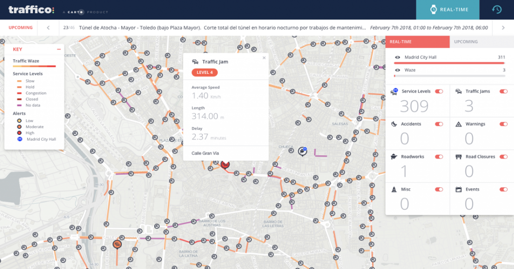
Commuter behaviour is changing in the face of increasing congestion and pollution. Trends such as crowdsourced traffic apps and embedded vehicle connectivity mean that urban planners and traffic managers need to capture the value of these new location data sources.


Smart Cities & IoT


Cities and governments globally are racing to make better use of actionable data when making decisions. Because so many government activities are inherently location-centric, accessing and understanding location-related data is critical. Citizens and stakeholders demand it, and agencies are being held accountable to the data they manage.


Citizen Services


Local governments exist to serve citizens, and citizens expect the same innovation from their governments as they see in society around them. More often than not, this means using location information to transform the way they deliver service and demonstrate their performance.


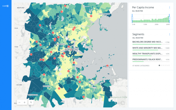
Public Participation and Open Data


Open Data has changed the way citizens see government, but leaders must be strategic in how they harness that data to solve specific problems. Since most open data is location-based, geospatial analysis is more crucial than ever. The best governments manage their location data and deliver it in an actionable format to their citizens, developers and employees. Make accountability easy with CARTO.


Urban Planning


Location data is crucial in planning more efficient and sustainable cities. Spatially analyzing mobility and citizen behaviour with internal and external data is crucial in order for urban planners to succeed in shaping the future of their cities with data-driven decision making.


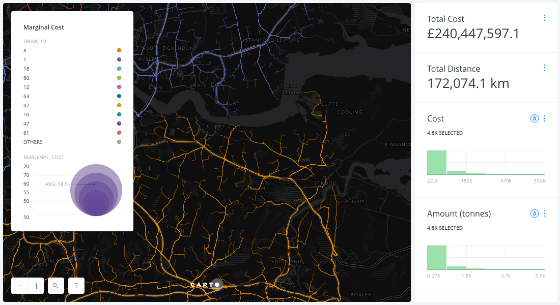
Fleet Routing & Tracking


Optimize your fleet’s performance, reducing costs and optimizing routing using Location Intelligence. Whether it’s road maintenance, waste disposal or healthcare visits – harness the power of CARTO to track your team, saving your organization valuable time and money.


Related subject

  • Location Intelligence Solutions
    10000
      Turn Location Data into Business Outcomes CARTO based solutions adapted to your business     For Business Analysts Escape the GIS Handcuffs Solve spatial challenges with third party location data streams, advanced spatial analysis, and interactive self‑service Location Intelligence applications. Put your location data to work to optimize business…
  • GIS
    10000
    GeoPoint has the human resources and know-how to present services and solutions in the area of solving territorial management problems. Geographic Information Systems for Territorial Management - Public Administration Topographic mapping and detail topography for project development; Dynamic wind models; Hydrological models; Relief models (3D, slopes, sun exposure, shade); Models…
  • Route Optimization
    10000
    Routes optimization in organizations can take many forms depending on the type, maturity, dimension and many other factors that characterize them. What are you looking for? 1. Integrate Location Intelligence into your systems 2. Access a full of functionalities software ready to make simulations and mobility studies (Desktop) 3. Access…

GIS

GeoPoint has the human resources and know-how to present services and solutions in the area of solving territorial management problems.

Geographic Information Systems for Territorial Management – Public Administration

  • Topographic mapping and detail topography for project development;
  • Dynamic wind models;
  • Hydrological models;
  • Relief models (3D, slopes, sun exposure, shade);
  • Models of potential solar radiation;
  • Architectural surveys for 3D model generation;
  • Land Registry;
  • Evaluations;
  • Expropriation projects;
  • Geographic information systems for heritage management and infrastructure
  • Topographic mapping and detailed topography for project development;
  • Object Oriented Image Analysis (OBIA) based on multi-spec images;
  • Automatic mapping of building details and communication routes;
  • Automatic mapping of vegetation cover;
  • Automatic mapping of water bodies;
  • Land Registry;
  • Spatial analysis and modeling using GIS tools;
  • Geographic information systems to support management.


Management and Protection of Ecological Areas and Fauna

Elaboration of habitat mapping (eg for Kisama National Park)

Tracking and monitoring of species (agros systems and related)

  • Production of topographic cartography for the detection of surface phenomena;
  • Spatial analysis and modelling using GIS tools;
  • Thematic cartography;
  • Habitat delimitation;
  • Flood maps;
  • Mapping for coastal management;
  • Cartography for water resources management;
  • Noise maps;
  • Development of cartography for environmental monitoring purposes;
  • Geographic information systems for managing environmental descriptors.


Geographic management system for Utilities

Waste Management

Objective: Provide garbage collection and treatment services with a system that allows a more efficient and efficient management of garbage collection, ensuring a better service to the population, environmental improvement and reduction of operational costs.

Why?

  • Making garbage collection more efficient by reducing the associated cost
  • Better control of human and material resources
  • Safeguarding the duration of the vehicles
  • Improve public health
  • Intelligent system, capable of adapting to real-time reality, and can be used for network redefinition projects, expansion or taking into account unexpected service interruption days.


Sanitation – Cadastre of the water supply network and expansion plans

Objective: Study the strategy of the supply and sewage network; To have a tool to support the decision and the operationalization of the tasks of maintenance, exploration and expansion of the network.

Why?

  • Knowing the infrastructure
  • Identify maintenance needs, manage interventions (what, where, when, next steps)
  • Designing network development based on real data


Energy and Communications

Objectives: Provide the energy services of a system that allows the management of the power grid, study its structure and expansion, or improve the operational control of repairs and maintenance, in order to better service to the population, have an environmental improvement and reduction of operational costs.

Why?

  • Knowing the infrastructure (equipment and network registration)
  • Identify maintenance needs, manage interventions (what, where, when, next steps)
  • Designing network development based on real data
  • Creating relief templates;
  • Spatial analysis and modeling using GIS tools;
  • Visibility studies;
  • Radio link profiles;
  • Choice of locations for the deployment of telecommunications antennas;
  • Geographic information systems for network planning and management.
  • Production of topographic cartography and detailed topography for the development of energy production, transportation and distribution projects;
  • Implementation, support and inspection of works;
  • Land Registry;
  • Evaluations of rustic and urban buildings;
  • Administrative easements;
  • Expropriation projects under the Expropriations Code;
  • Geographic information systems for the management of energy transmission networks; < li>


Addressing and territorial management

Many developing areas experienced very large urban growth, characterized by the emergence of many sub-equipped neighbourhoods. The previous systems of identification of the routes usually applied in the old quarters of the center of the city, rarely were extended to the new quarters. This is a worrying situation for the functioning of urban services. With no identification system, how can you locate yourself in a city that is still growing? How to quickly guide ambulances, firefighters, and security services? How to send correspondence or messages and orders to the home? How to identify the urban equipment? How to locate faults in water, electricity and telephone networks? How to make tax collection services work?


Emergency Vehicle Management, Monitoring and Control System

Vehicle Tracking and Dispatch Optimization:

  • Police
  • Firefighters
  • Medical emergency
  • Control Room


Related subject

  • Toponymy
    55
    Toponymy is the study of place names (toponyms), their origins, meanings, use, and typology. GeoPoint has experience in the implementation of toponymy in Portugal. In particular: Toponymy Municipal Regulation Diagnostics of toponymy status, including port numbers Data Organization and Fieldwork Manual Fieldwork Training Fieldwork, survey of streets and door numbers…
  • Route Optimization
    45
    Routes optimization in organizations can take many forms depending on the type, maturity, dimension and many other factors that characterize them. What are you looking for? 1. Integrate Location Intelligence into your systems 2. Access a full of functionalities software ready to make simulations and mobility studies (Desktop) 3. Access…
  • On premises Server
    44
    GeoOptimization Server: The planning and route optimization web service GeoOptimization Server, a route optimization web service, adds planning and geographical optimization features to existing information systems. Can be easily integrated with existent systems like SAP, Primavera, PHC, Oracle, SAGE, Dynamics, SalesForce or others: multi-constraint optimization, geocoding, redistricting and routing. The…

Software Development

 
The development of custom applications in companies is becoming more common, showing the full potential of the applications and ERPs used, thus obtaining an extra profitability by exploiting the potential of the connection to the base applications.

The customization of software and ERP’s or the development of a specific root solution for each business, leads to productivity ratios with results that are unquestionable.
GeoPoint has the capacity to identify, analyze and model its needs, developing tailor-made solutions on various technological platforms for the most diverse areas related to territorial management and geographic intelligence.

Integrate Location Intelligence into your solution

Most common integrations:


Technology we care about:

PostgreSQL/PostGIS · CARTO · GeoConcept · QGIS · GDAL · GEOS · D3.js · Leaflet · Google Maps · HERE Maps3 · WhirlyGlobe · Python · R · Node.js · Docker · AWS · Spark · SciPy · NumPy · Pandas · Theano · TensorFlow · GeoWave · GeoMesa

Analytics


We help business capturing all the value from their and our data
and transform it into a sustainable competitive advantage

Analytics is the discovery, interpretation, and communication of meaningful patterns in data. Especially valuable in areas rich with recorded information, analytics relies on the simultaneous application of statistics, computer programming and operations research to quantify performance.

Organizations may apply analytics to business data to describe, predict, and improve business performance. Specifically, areas within analytics include predictive analytics, prescriptive analytics, enterprise decision management, descriptive analytics, cognitive analytics, Big Data Analytics, retail analytics, store assortment and stock-keeping unit optimization, marketing optimization and marketing mix modelling, web analytics, call analytics, speech analytics, sales force sizing and optimization, price and promotion modelling, predictive science, credit risk analysis, and fraud analytics. Since analytics can require extensive computation (Big Data), the algorithms and software used for analytics harness the most current methods in computer science, statistics, and mathematics.

Descriptive & Diagnostic Analytics

Visualize and analyse your data for better understanding and decision making

Hindsight: “What happened?” Oversight: “What is happening?”

  • GIS
  • Databases
  • Dashboards
  • Business intelligence
  • Web data extraction
  • Data cleansing
  • Problem structuring
  • Data and model visualization
  • Descriptive statistical analysis
  • Data exploration and pattern detection


Predictive & Inquisitive Analytics

vizualize_carto_location_intelligence
Learning: “Why does it happen?” Foresight: “What will happen?”

Diagnose: ‘Why did something happened at a certain moment in the past ?”. Use a variety of statistical, modelling, data mining, and machine learning techniques to study recent and historical data in order to make predictions about the future.

  • Inferential statistical analysis (controlled experiments, non-parametric techniques)
  • Data mining & Machine learning (classification, regression, factor analysis, clustering, deep learning, reinforcement learning)
  • Forecasting and Prediction
  • Simulation, Risk, Uncertainty, and Scenario Planning


Prescriptive & Optimization Analytics

Insight: “How should it happen?”

  • Optimization & planning (heuristics, mathematical programming, constraint satisfaction, solvers)
  • Multicriteria evaluation
  • Portfolio optimization & resource allocation
  • Project planning and resource scheduling
  • Behavioral sciences & nudging
  • Negotiation, conflict, and game theory


Related subject

  • Location Intelligence Solutions
    78
      Turn Location Data into Business Outcomes CARTO based solutions adapted to your business     For Business Analysts Escape the GIS Handcuffs Solve spatial challenges with third party location data streams, advanced spatial analysis, and interactive self‑service Location Intelligence applications. Put your location data to work to optimize business…
  • GeoMarketing
    72
      As a provider of an integrated and complete offer in the GIS and GeoBI areas, GeoPoint's offer is not limited to consultancy and complete software implementation, but also to the development of customized, fully customized studies and services. GeoPoint combines your information with population, market and economic data, using…
  • Retail
    65
    Take on the growing threat of ecommerce with location data and leverage demographic and socioeconomic data to redefine customer engagement.   Site Planning 90% of retail transactions still take place offline. Whether it’s opening, closing, repurposing or relocation - let Location Intelligence power your gravity modelling. Create a profitable offline…

Training

GIS training for companies

With more than 150,000 hours of training, GeoPoint, in addition to its e-learning offer, offers the possibility of carrying out GIS training actions tailored to its clients, aimed at companies or pre-organized groups.

We can adapt any content to your needs!

As a standard offer we have GIS courses in the following areas:

  • Introduction to GIS
  • Introduction to QGIS
  • Management of Spatial Databases
  • Editing, Data Processing and Spatial Vector Analysis
  • Matrix Spatial Analysis – Raster
  • 3D Spatial Analysis
  • GeoMarketing
  • Toponymy and Addresses
  • WebGIS

GIS training in e-learning

Unfortunately, at this time, we only have Portuguese content. By the way, did you know that Portuguese is the 6th most spoken language in the world?

If you have any special requirement regarding GIS e-learning sessions in English, don’t hesitate to contact us!


Related subject

  • GIS
    41
    GeoPoint has the human resources and know-how to present services and solutions in the area of solving territorial management problems. Geographic Information Systems for Territorial Management - Public Administration Topographic mapping and detail topography for project development; Dynamic wind models; Hydrological models; Relief models (3D, slopes, sun exposure, shade); Models…
  • Territory Management
    31
    Accessible, simple, fast and efficient, Geoconcept Territory Manager is the benchmark web solution for fairly apportioning operations, teams and resources on a geographical basis. Sales managers, schedulers and decision-makers can use this intuitive tool to define powerful go-to-market strategies! Territory management Sales sectors, delivery and service call areas, zoning Efficient…

Location Intelligence Solutions


Turn Location Data into Business Outcomes

CARTO based solutions adapted to your business


For Business Analysts

Escape the GIS Handcuffsvizualize_carto_location_intelligence

Solve spatial challenges with third party location data streams, advanced spatial analysis, and interactive self‑service Location Intelligence applications. Put your location data to work to optimize business processes and predict future outcomes, leading to more efficient delivery routes, better behavioural marketing, strategic store placements and more.


For Data Scientists

Inject Location Intelligence into
your data science workflows

Interactively analyse and visualize location data directly in your Jupyter Notebook workflows. Enrich data from any source including Hadoop and AWS with third party location data streams and make accurate business predictions and spatial models from a single environment.


For Developers

The Modern Way to Build Location Intelligence Apps

Create powerful and flexible location solutions with fully customized look and feel. Skip the complicated GIS developer libraries and backend setup to focus on creating elegant and responsive business user experiences. Jumpstart location app development and deliver business outcomes exactly as required.


Related subject

  • Analytics
    78
      We help business capturing all the value from their and our data and transform it into a sustainable competitive advantage Analytics is the discovery, interpretation, and communication of meaningful patterns in data. Especially valuable in areas rich with recorded information, analytics relies on the simultaneous application of statistics, computer…
  • GeoMarketing
    72
      As a provider of an integrated and complete offer in the GIS and GeoBI areas, GeoPoint's offer is not limited to consultancy and complete software implementation, but also to the development of customized, fully customized studies and services. GeoPoint combines your information with population, market and economic data, using…
  • Retail
    70
    Take on the growing threat of ecommerce with location data and leverage demographic and socioeconomic data to redefine customer engagement.   Site Planning 90% of retail transactions still take place offline. Whether it’s opening, closing, repurposing or relocation - let Location Intelligence power your gravity modelling. Create a profitable offline…

Recent Posts

  • Olá, mundo!

Recent Comments

    Archives

    • June 2018

    Categories

    • Sem categoria

    Meta

    • Log in
    • Entries feed
    • Comments feed
    • WordPress.org

    Tags

    address parsing Analytics carto dados data bases data bases data science delivery route eficiency endereços geocoding geomarketing georreferenciação GIS Government Healthcare integration IOT Local Government Local Government Management location intelligence logistics logistics Mobility moradas MySQL normalização optimization pharma route optimization route optimization route planners routing sales efficiency Sales Force Automation Sales Force Effectiveness SFA SFE Smart Cities software toponymy toponímia training transportes transports

    Website

    • Software Development
    • Route Optimization
      • Cloud Solution for Route Optimization
      • On premises Server
      • GeoOptimization API
    • GIS
    • Location Intelligence Solutions
    • Territory Management
    • Careers
    • Analytics
    • GeoMarketing
    • Outsource | Nearshore | Offshore

    Contacts

    Quinta da Fonte
    Rua dos Malhões, Ed. D. Pedro I
    2770-071 Paço de Arcos
    Portugal

    Phone: +351 21 387 95 57

    e-mail: geopoint@geopoint.pt

    Suport: suporte@geopoint.pt

    Follow us

    LinkedIn
    YouTube

    Accredited Entity for Cartography Production

    © GeoPoint 2022 - all rights reserved
    Theme by Colorlib Powered by WordPress