Integrations
Connect your data to our Location Intelligence and Routing solutions
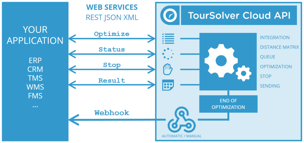
Our products and solutions can be easily integrated into numerous application environments, thereby enabling web services to be implemented in Internet and Intranet architectures. It adapts to every kind of database and international grammar. An easy-to-integrate Rest API confers complete mastery of the optimization process.
Even though, we offer some connectors ready to work such as:
DATABASE CONNECTORS:

MySQL: Expand the geospatial capabilities of one of the most popular databases
Microsoft SQL Server: Enable the power of location on your Microsoft database instance
PostgreSQL: Externally connect to your PostgreSQL object-relational database
Amazon Redshift: Massive and advanced parallelized Location Intelligence in the cloud
Hive: Accelerate your distributed data infrastructure with Location Intelligence
CLOUD STORAGE

DropBox: The easy-to-use file sharing and storage service, directly integrable with CARTO
Google Drive: Connect and access spreadsheet from your Drive directly with CARTO
Box: Connect CARTO to the business-grade cloud file sharing service you love
THIRD PARTY TOOLS
ArcGIS: Connect to ArcGIS™ Server layers directly from CARTO
Qlik: Real-time connection with their business intelligence dashboards in the cloud
Splunk: Location intelligence on your machine-generated data management platform
Alteryx: Transform and analyze your data from Alteryx and geo-spatially accelerate it with CARTO
OTHERS

Twitter Maps: Map the pulse of the world directly through our Firehose advanced connection
Excel Data: Transform your spreadsheets data into location insights
Digital Globe Satellite Imagery: Freshly baked high-resolution satellite imagery, straight into CARTO
Bird.i: Bring your CARTO map to life with the most up-to-date satellite images
Related subject
- 10000The development of custom applications in companies is becoming more common, showing the full potential of the applications and ERPs used, thus obtaining an extra profitability by exploiting the potential of the connection to the base applications. The customization of software and ERP's or the development of a specific…
- 10000Turn Location Data into Business Outcomes with GeoMarketing solutions Solutions adapted to your business For Business Analysts Escape the GIS Handcuffs with GeoMarketing Solutions Solve spatial challenges with third party location data streams, advanced spatial analysis, and interactive self‑service Location Intelligence applications. Put your location data to work…
- 10000Our offer would not be complete without providing data packages that could boost our clients' studies. We have our own data and data from a vast network of international partners that we can include in our packages. In addition to the wide range of maps, GeoPoint also provides statistical…