
Route Optimization and Distribution Management
The optimization of routes in organizations can take various forms depending on the type, maturity, size, and many other factors that characterize them. What are you looking for?
- A user-friendly solution, accessible anywhere?
- Integration of route optimization capabilities and geographic intelligence into your business?
- A complete distribution management solution integrated with your ERP, CRM, or billing software?

1. TourSolver Cloud

Optimize your routes. Simple.
Get realistic and profitable route plans for your delivery team, sales personnel, technicians…
Monitor the compliance of each route in the field, thanks to the dedicated mobile app.
Using TourSolver Cloud happens in 4 steps:
- My Activity
Define the country you are working in and the terminology you want to use to configure the tool in the specific language of your business: this should include the types of vehicles used and application preferences to turn TourSolver Cloud into your own customized business solution for your needs and strategies.
- My Resources
Create your team in just a few clicks, including resource characteristics such as their location, time windows, and key constraints to be applied.
- My Visits
Import or drag and drop your file of clients to be visited. This can be done from an existing template. These clients will have their locations stored as geographic data and will be ready to be optimized.
- Optimization and Results
The optimization engine will calculate the best solution and present results that can be exported to various formats.
Mobile App
The TourSolver Cloud has an app available on Google Play.
This app allows field personnel to access their activity planning, information about each client, declare the status of the visit (done or not done – in addition to the default state of “to do”), and the best route to reach the next client (external apps like Google Maps, Waze, Here…).
In addition, in the Browser Version, the supervisor can access the status of declared visits (to do, done, or not done).

Watch the Video
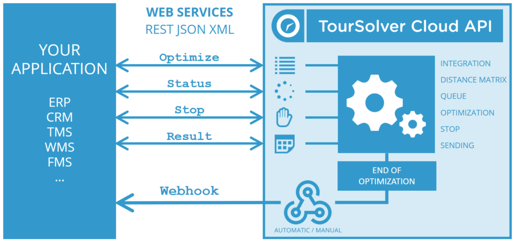
2. TourSolver API

// Add Route Optimization*
// to your platform. Simple.
Simplify the lives of your users by making route optimization central to your ERP, CRM, TMS, WMS, FMS applications…
* and also maps, geocoding, and many other features!
Put route optimization at the heart of your application.
Offer your users the unique experience of geo-optimization and provide practical solutions all at once!
Simplicity and Integrity in an API
The TourSolver REST API provides easy integration of a web service to optimize routes and retrieve results. Webhooks can be configured so that results are automatically received as soon as the optimization is completed. Fast and easy to implement.

Complete Range of Web Services
The variety of web services meets all your route optimization requirements:
- Initiate optimization
- Track optimization status
- Stop optimization
- Receive optimization results as a whole or route by route
- Webhooks can be configured to automate result reception.

API Clients
Client-side libraries are provided for adaptation to the application context:
- JavaScript
- Java XML
- C# / .NET
- PHP JSON
- PHP XML

APIs for All Types of Geo-Optimization
If you need additional services:
- Geocoding of addresses
- Mapping
- Route calculation
- Search around
- Isochrone and isodistance calculation
- And much more…
Enhance your TourSolver experience with our Geo-Optimization API.
More information here: [English Geo-Optimization API](https://www.geopoint.pt/optimizacao-de-rotas/english-geooptimization-api/)
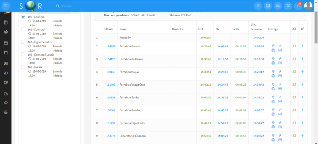
3. SOR Distribution Management Platform
Management Interface
– Manage Vehicles (Create, Modify, Delete)
– Manage Customers (sync with ERP/WMS)

– Manage Warehouses
– Manage orders/products
– View customers by tier
– Generate Routes (invoke TS API or not)

– Send Routes to devices
– (app and excel via email)
 |
 |
 |
 |
–
 |
|---|
– Signature collection and delivery confirmation

– Barcode scanning
– View route history
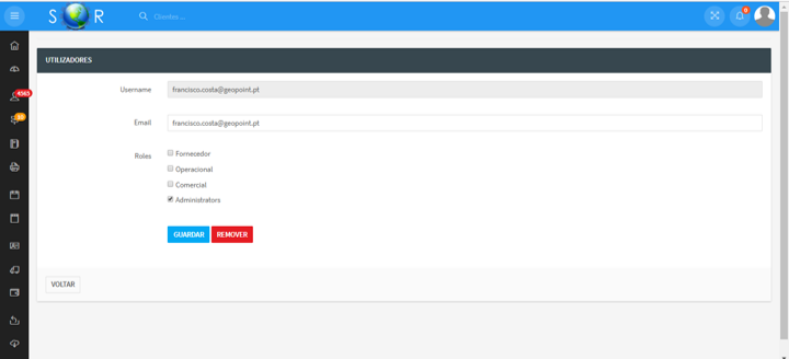
– Access management
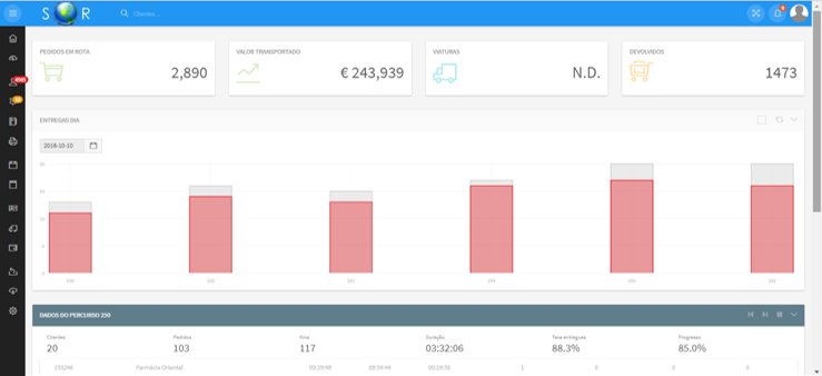
– Dashboard
– Integration with external systems (Primavera, PHC, SAP, others)
Configurable Variables – Route Optimization
Clients
- Days, time windows, visit frequencies
- Punctuality, penalties for delays
- Fixed and variable visit time, unloading time
- Required characteristics (skills, vehicle…)
- Street-side management
- Quantities (up to 24 products or dimensions)
- Assign clients to a route.
Resources
- Days and working hours, lunch break
- Overtime hours
- Characteristics (driver skills or vehicle qualities)
- Assign different starting and ending locations for shifts
- Capacities (up to 24 products or dimensions)
- Cost-Distance, cost per hour, overtime cost, overnight cost, distance threshold cost
- Fixed usage costs, delivery costs, fixed cost per visit
- Delivery and pick-up
- Driving hours legislation
- Overnight routes (nights out)
- Multi-depot Management
Road Network and Vehicles
- Avoided areas
- Traffic statistics *
- Different types of vehicles
- Speed configuration for each type of road
- Use or not toll-free roads
- Attributes of heavy vehicles**:
– Weight and height with 16 variables for each;
– Length and width of the vehicle;
– Vehicle with trailer;
– Transportation of hazardous materials;
– Material of flammable materials;
* Depending on countries ** Depending on information available in the road network databases
Related subject
- 10000// Add route optimization* // to your platform. Simply. Simplify life for your users by making route optimization central to your ERP, CRM, TMS, WMS, FMS applications … * and also maps, geocoding and many other benefits! ! Put route optimization at the heart of your…
- 10000GeoOptimization Server: The planning and route optimization web service GeoOptimization Server, a route optimization web service, adds planning and geographical optimization features to existing information systems. Can be easily integrated with existent systems like SAP, Primavera, PHC, Oracle, SAGE, Dynamics, SalesForce or others: multi-constraint optimization, geocoding, redistricting and routing. The…
- 10000Optimize your routes. Simply. Get some realistic and profitable route plans for your delivery staff, sales people and technicians respecting all time windows. Follow each route's fulfilment in the field, thanks to the dedicated mobile app. The use of TourSolver Cloud takes place in 4 steps: My…


 Traffic Management